
Radio Brisvaani

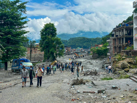
New Delhi, Aug 29 (IANS) Nepal’s devastating flash floods serve as a reminder of the urgent need for regional collaboration, where countries under the shadow of the mighty Himalayas need to adopt a diplomatic narrative that includes ecological security as an important part of relationships, exert reports.
Popular Nepali newspaper Kantipur Friday observed that it is time for Kathmandu to immediately start working on disaster diplomacy and on the agreement with Beijing on its “implementation modality” and “framework”.
Incidentally, China and Nepal had agreed to share cross-border real-time information on floods and landslides and flag potential risks of glacial lake outburst floods. However, no formal agreement has been signed yet to implement such a mechanism despite Nepal Foreign Minister Shisir Khanal having raised the issue during his China visit in May.
Such reports emphasised the need for sharing information and cooperation in disaster reduction, where long-term risks should be taken into account in the construction of strategic structures such as roads, bridges, and hydropower projects near international borders.
Parliamentarians from across the Hindu Kush Himalaya (HKH) region too had insisted on Wednesday, as news of the devastation emerged, that the tragedy underscored the urgent need for stronger regional cooperation to address climate risks that transcend national boundaries.
They were meeting for the two-day 2nd Hindu Kush Himalaya Parliamentarians’ Meet in Thimphu, where a moment of silence for the victims and their families was also observed, according to the International Centre for Integrated Mountain Development (ICIMOD), an intergovernmental knowledge and learning centre working on behalf of the people of the HKH.
Participants said the disaster highlighted the importance of collective action, stronger preparedness, and sustained regional cooperation to reduce climate-related risks and build resilience across the HKH region. ICIMOD is based in Kathmandu, and works in and for eight regional member countries – Afghanistan, Bangladesh, Bhutan, China, India, Myanmar, Nepal, and Pakistan. The body later examined satellite imagery and concluded that “a massive rock–ice avalanche occurred in Nepal, blocking the Lhende River and triggering cascading floods downstream”.
Their assessment pointed not to tectonic activity but to glacial instability, a phenomenon increasingly linked to climate change. This was corroborated by the US Geological Survey (USGS), which earlier took the tremor as an earthquake.
In a revised statement, the USGS stated that additional analysis of seismic waves and satellite imagery led to the determination that the seismic event was rather a glacial collapse and debris flow, and that no earthquake had occurred. Global warming and construction in nearby areas are largely being seen as the reason for the avalanche, though the actual reason may take some time to be identified, pointed reports.
Some experts compared such glaciers on mountains to cement that helps hold a building together. Mongabay, a US-based non-profit conservation and environmental science news platform, also said that the floods were triggered by a glacier collapse and landslide into a river on the Tibet-Nepal border.
Like other reports, it assumed climate change had loosened the ice “till the entire mountainside, including a glacier clinging to it, collapsed into the river flowing some 3,000 metres below”.
Pointing out that no early warning system would have helped those who were close downstream when the huge chunk and debris fell on Wednesday, the article stated that one way to manage this risk is to be able to predict such a disaster with a credible probability level, so that governments can take protective action. This, it emphasised, would need countries to comprehensively map all icebound slopes above a certain gradient. In the face of such reports, the HKH countries would need to step up research, share data, and coordinate seamlessly to be prepared for such calamities.
–IANS
jb/uk